Measuring Building Setbacks
 At the time of the foundation inspection, the building inspector will measure the “setback distance” between the proposed structure and the property line or edge of a road easement – whichever is closest. This requires clearly visible permanent monuments set by a professional land surveyor or registered civil engineer, or temporary “intervisible stakes” placed (and labeled with license number) by the surveyor or engineer (EDC Code 15.16.060). In lieu of the above, a letter stamped and signed by the surveyor or engineer may be provided stating that the foundation is located in accordance with the setback distances shown on the approved plans.
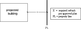
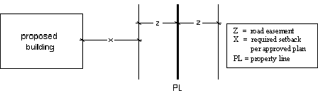
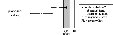
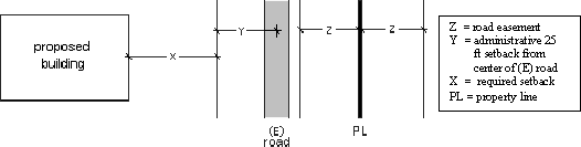
Building setback distances are measured perpendicular to the property line or edge of a road easement, whichever is the closest to the proposed structure. See the illustrations below for examples:
(1) Where there is no road easement or roadway:
(2) Where a recorded road easement exists on the property (easement is shown on a Parcel Map, Subdivision Map, Record of Survey, or other recorded document such as a Grant Deed):
(3) Where there is no recorded easement, but there is a roadway:
(4) Where a recorded easement exists, but roadway is located outside of the easement. In this case, the edge of the administrative easement takes precedence over the recorded one:
Questions regarding setback distances may be directed to Planning Services.